Inside Fukushima – Part 3

Read part 1 and part 2 first.

I take a last look, tracing the wall with my eyes to where it vanishes into the distance. Visible on the horizon is a tall chimney that belongs to the Haramachi power station, not a nuclear power, but a coal processing plant. Huffing and puffing white vapor into the sky, the smoke proves it is running again. Having been severely damaged by the earthquake and tsunami, the plant was relaunched in spring 2013. I am thus reminded of the fact that the disaster at the Fukushima Daiichi power plant was not the only plant accident resulting from the massive natural impact of the earthquake and the Tsunami waves, which reached up to around 30m in some areas. As well as the Haramachi plant, several other thermal and nuclear power plants were damaged by the Tsunami.[1] However, the terrific outcome at the Fukushima Daiichi of a Maximum Credible Accident (MCA) was arguably the only man-made disaster resulting from the natural disaster, human error giving bearing the 3/11 disaster a radioactive triplet.

sternmap
Condition of Japan’s nuclear reactors as of May 2011. Source: http://www.spiegel.de/international/world/bild-764907-219565.html

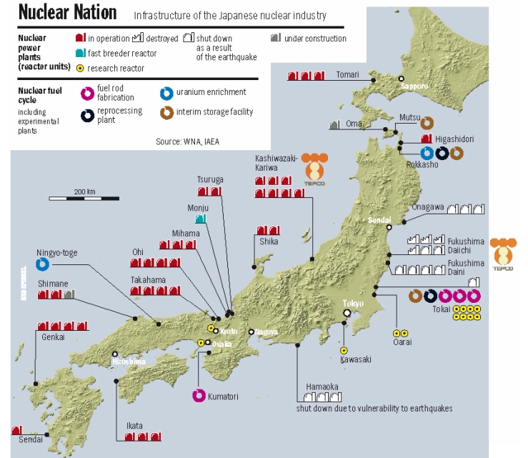
Along Tohoku’s eastern shoreline the prefectures of Fukushima, Miyagi, and Aomori have nuclear power plants (NPP) that were affected by the earthquake and Tsunami.[2] Aomori’s Higashidori NPP luckily was in maintenance shutdown when the disaster struck. However, the severe aftershocks that came about a month later on the 7th of April with a magnitude of 7.1 caused a power outage at the plant. Nevertheless, plant failure was avoided and the reserve system worked fine.[3]

After initial complete shutdown, as of the 10th of March 2016, only one of the 43 operable nuclear power plants of Japan, the Sendai plant is running again. However, under the guide of President Shinzō Abe’s pro-nuclear political agenda many more are awaiting their restart.[4] The recklessness of such an energy policy seems all the more apparent after the recent 7.0 magnitude earthquake in April 2016 in Japan’s southwest on the island of Kyushu.  What irony to have the strongest earthquake since 3/11 strike so close to Japan’s only running plant. The feeling of discomfort caused by the alterity of this dystopian landscape doesn’t leave me when I get back in the car and we start driving again. We are still outside of the exclusion zone.

fuku8

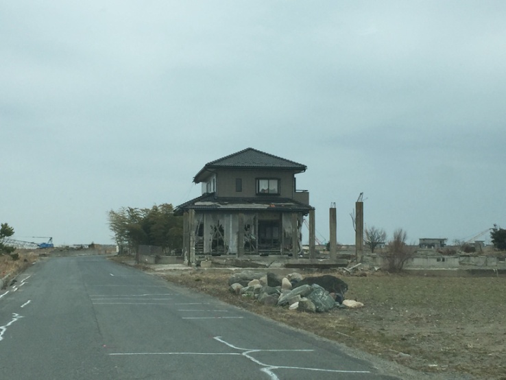
On our way closer to the Daiichi, we pass a couple of houses partly dismantled and severely damaged by the natural disasters. The bottom floor pulled away, standing like a stilt house, screen shields in flares, windows and panels removed, like someone took it and shook it violently, outside of the exclusion zone these houses are a rarity now. The areas outside of the strictest no-access zone are already cleaned meticulously. With their superimposed decontamination grid lines they have an almost sterile and orderly feel to them.

fuku10
Source: http://www.meti.go.jp/english/earthquake/nuclear/roadmap/pdf/150905MapOfAreas.pdf

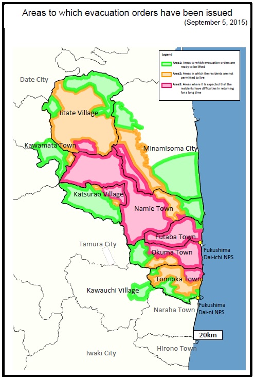
Throughout the last five years since the disaster, the demarcation lines, zones and checkpoints have been anything but rigidly fixed. The initial exclusion zone of the 20km evacuation radius around the Fukushima Daiichi power plant has been transformed into areas with different levels of access restrictions and security measures. Besides the strictest no-go exclusion or difficult-to-return zone closest to the power plant, there are those that can be accessed for short periods of time, as well as areas where evacuation orders are ready to be lifted. The zone at the core is off-limits to the public, special entrance permits are required to access it and even former residents are only allowed in for short periods of time around a dozen times per year. While you don’t need an official permission the second stage zone is accessible only during day time and any kind of business is prohibited. However, even these demarcations are continuously in flux, and we are surprised to see a checkpoint at a previously accessible road.

fuku9
A checkpoint into the restricted area.

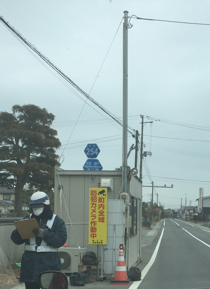
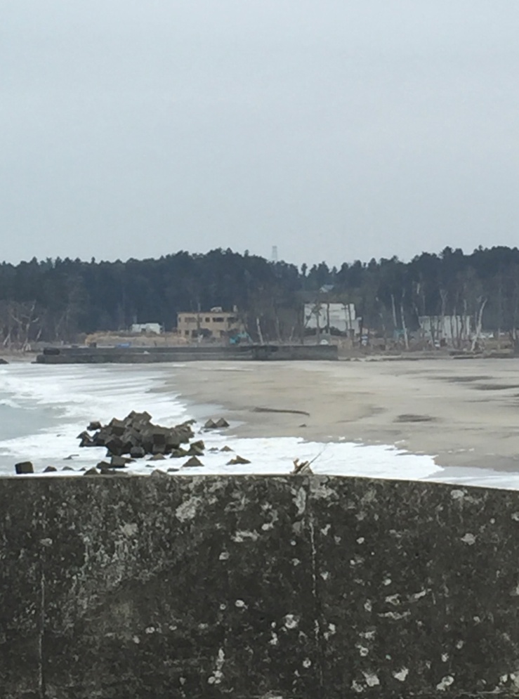
We revert to using a white lie and the guard grants us access. He notes down our number plate and we are free to pass into the restricted area. There are more carcass-like housing structures here, but I am surprised at how busy this area is, less than 6km from the power plant’s smoldering reactors. There are construction workers around. Former residents digging up their belongings from beneath the foundation walls of their houses that look like Roman ruins now. Even the Geiger counter confirms a radioactive contamination that is less than that measured in some parts of Tokyo. Governmentally inflicted borders are somewhat arbitrary and free to interpretation after all. Radiation doesn’t stick to a superimposed boundary and there hardly ever is a strict division between the here and there, the inside and the outside of the zone; except maybe for the linguistic labels that us humans stick to certain geographic terrains. Instead, the here and there of the Fukushima exclusion zone and the rest of Japan, or even the rest of the world, is metaphorical and hardly comprehensible at all. As I stand by the ocean, the chimney of the Fukushima Daiichi peeking out from behind some trees in front of me, I think about the impossibility of discerning where the fiction the nuclear catastrophe and its zone ends and where its reality begins. Radioactive contamination is elusive, and so are the ecologies it creates. I turn around: this is as close as I will get to the heart of the disaster, this time.

fuku11

[1] https://www.tohoku-epco.co.jp/ir/report/annual_report/pdf/ar2012_p08p11.pdf‘

[2] There are no nuclear power plants located in Iwate.

[3] Besides the Higashidori NPP, Aomori is also the location of the Rokkasho Repossessing Plant, a nuclear waste dump, uranium enrichment and plutonium processing facility.

[4] http://www.nei.org/News-Media/News/Japan-Nuclear-Update

All images and content ©Theresa Deichert, 2016.

Inside Fukushima – Part 2

Read part 1 here.

Saturday, 05.03.2016:

The next day the journey continues towards the shore and closer to the hotspot of the nuclear disaster, the Fukushima Daiichi. More mountain ranges of black decontamination bags are passed. The tallest ones, which measure three or more stories of bags are half shielded by walls of grey-blue panels. At the end of the day it is all about appearance; out of sight out of mind, or so the saying goes. Since day one of the catastrophe, the Japanese government and TEPCO (the Tokyo Electric Power Company) have worked and continue to work hard to “save face.”  To convey an impression of control over the sheer untamable situation at the Fukushima Daiichi and the surrounding exclusion zone seems to take first and foremost priority. There is not only the hard working public relations machine of the electric power company itself, but additionally also a severe lack of credible journalistic reporting by the national press.[1] The latter is due to the structure of the Japanese press system, in which journalists often have to undergo self-censorship in order to secure their jobs and future access to governmental sources.[2] Subsequently, one may notice big discrepancies between the national and the international press in terms of the reporting on the gravity of the ongoing meltdown. However, governmental cover-ups and secrecy are only one of many misconducts related to the issue. Sub- and sub-subcontractor structures (and the involvement of the Yakuza) are determinant of the way workers are employed at the plant and for decontamination work. This results in great salary gaps between individual workers, ranging from exorbitant compensation to a below-minimum-wage payment for some.[3]

fuku6
Mountains of decontamination bags

Driving past the busy-bee workers, I am told that, while the decontamination workers visible from the highway are required to wear their protective suits and masks, those further away and shielded from sight are not, and often remove the uncomfortable gear during the hot summer months. However, radiation is patchy and unpredictable. Some areas in the vicinity of the nuclear plant measure doses as low as 0.02 μSv/h. The fallout, spread by wind and rain, does not stick to human-imposed zones or artificially drawn borders. Nor does it stay where it once settled. Decontaminated school- and playgrounds are often re-contaminated through soil or dust that is blown in by the wind from other, still contaminated areas, which are often way too close to those decontaminated.

fuku7
A sign documenting the reconstruction efforts. Taken Saturday, 05.03.2016, 12:02:48

At around noon we make our way towards the ocean. Large plates beside the road document the reconstruction efforts and proclaim that it has reached 91% as of the end of November 2015. Besides a large graphic showing the construction matrix of the tsunami wall, photographs along the bottom of the sign document the development of the area beginning in 1963 (Showa 38) up to 2013 (Heisei 25). Where the Tohoku earthquake and tsunami happened, a photograph is missing. Instead black letters on white ground indicate zero hour. The last square of the succession still remains empty, a blank slate left open for the final photograph, as if to say a bright future is still possible. I sense propaganda on every corner, but I am also not sure whether I have just become overly critical?

fuku5
The Tsunami Wall. Taken Saturday, 05.03.2016, 12:08:00

Then, close to where the Minamisoma ward of Kitahara once stood, we reach the shore.[4] Despite that it is a sunny day, the landscape seems dismal. Behind us there are fields of Tsunami-emptied land, trees washed away or bend like matches, the larger vegetation reduced to patches that sit like little hoods on the remaining hills. And in front, there it is: the Wall. Defining the view, this massive concrete construction stretches from horizon to horizon, as far as the eye can see. White washed and immaculate, the Wall is something that crept out of your latest science-fiction nightmare, a real life dystopia. Stretching along Japan’s Eastern coastline, each of the Prefectures along the shore have begun to construct tsunami protection walls, which once joined, will stretch more than 300km along the coastline.[5] However, the construction of this protective barrier against nature’s unpredictable forces has been the source of many controversies. While some scientists have argued that it will disturb the marine ecology, others argue that it might not even be effective. Instead of alleviating the effects of a tsunami and warding off the water masses, they argue that the Wall will keep them from flowing back into the ocean, creating a deathly pool of water on the land.

fuku4
The tsunami wall with the Haramachi power station in the distance, which was severly damaged by the tsunami.

(To be continued in the last part, where I enter the exclusion zone…)

[1] http://www.spiegel.de/international/world/japan-s-nuclear-cartel-atomic-industry-too-close-to-government-for-comfort-a-764907.html

[2] http://www.japantimes.co.jp/news/2015/02/25/national/media-national/japanese-media-self-censorship-seen-growing-abes-reign/

[3] https://www.rt.com/news/fukushima-workers-nuclear-yakuza-006/

[4] Close to Kitahara Kashimaku Minamiebi, Minamisōma-shi, Fukushima-ken 979-2312, @37.7095073,141.0023834

[5] http://www.independent.co.uk/news/world/asia/japan-to-build-250-mile-long-four-storey-high-wall-to-stop-tsunamis-10131013.html

All images and content ©Theresa Deichert, 2016.

Inside Fukushima – Part 1

Friday, 04.03.2016

We start the trip at 9:40am and leave Tokyo headed in north-westward direction. We drive along the highway through Chiba Prefecture and towards Ibaraki Prefecture. After shortly stopping in Iwaki City, we continue to follow the Joban Expressway up North. This highway which spans around 300km in its entirety had been closed off in a 20km radius between Hirono and Tomioka after the Fukushima disaster and was only accessible with an official exemption certificate issued by the government authorities. However, it was reopened to the public on the 22nd of February 2014.[1] Shortly after, the construction of the route Namie to Minamisoma was continued and finished on the 6th of December 2014.[2] The last part, a 14.3 km long stretch between Namie and Jobantomioka was finally opened on the 1st of March 2015. Radiation exposure is displayed at 6 points on this route.

fuku1
A plate along the Joban Highway showing the outside radiation in micro Sievert per hour. Taken Friday, 04.03.2016, 16:36:08.

Driving along the highway, overhead plates show the current radiation exposure in micro Sievert per hour. Somewhere close to the town of Tomioka (Futaba district) the measurement increases to as high as 5 μSv/h (micro Sievert per hour). To put these numbers in perspective, whereby 10 μSv/h translates to immediate physical danger and an urgent requirement to relocate at once, 5 μSv/h presents a high risk of harm and requires you to relocate as soon as possible; even as low as a number as 2 μSv/h presents an elevated risk and the need to take safety precautions. At the moment of the highest outside radiation the Geiger counter does indeed show the value measured inside of the car as 2 μSv/h. Not only the urgent piercing beep of the counter makes this experience a stressful one, but also knowing that even inside the car, whose metal plates act as a shield from radiation exposure, the radiation is so strong as to pose an immediate threat to human health made me feel extremely uncomfortable. Never having been knowingly exposed to such an amount of radiation at once, for such an extended period of time, I feel like I can sense my body being irradiated. This is of course impossible, but serves as a personal proof of the way in which something so intangible and invisible, and at the same time so hostile to the human organism, could cause severe mental stress and a feeling of being reduced to ones bare and unprotected life. I remember my father’s concerns about this trip and cannot help wondering if, in this very moment, I am doing anything harmful to my potential future offspring.

fuku2
One of many radiation measurements inside the car. Taken Friday, 04.03.2016, 16:41:50.

The view along the highway is defined by fields whose surfaces have been lowered to a few decimetres. This reduction of surface level is due to the extensive excavation of irradiated soil, which in strenuous, labor-intensive work is dug up and stored in massive black bags. The latter are even more defining of the landscape than the strangely lowered squares of land. The black bags are almost everywhere. Rows and rows, mountains next to mountains of squarish bags bursting full with dirt, once source of life, they are now through the impact of human technology turned into toxic radioactive waste.  I ask myself, from this moment onwards, what is this matter that they contain? Is it nature or is it something else?

fuku3
Rows and rows of decontamination bags, filled with radioactive soil.

The night is spent at a local Ryokan in Minamisoma-Shi, a city who has been severely affected by the impact of the Tsunami. Being located high enough on a hill the elderly owners’ house was just spared by the hungry flood. However, due to the radioactive contamination all around they had to discontinue their occupations as organic farmers. In an attempt to keep his most prosperous collecting spots a secret and maybe also in a desperate grip on normalcy, the husband, Mori-San, continues to collect the local Hatsutake mushroom. This is a mushroom variety, which is highly sought after, but as mushrooms tend to pull out the radioactive elements from the ground, it will remain inedible for the next decades, maybe centuries. Mori-San and his wife tell stories of how gravely the local community was affected by the disaster. When the Tsunami ate its way inland many citizens evacuated to a Shrine, located at the top of a hill. However, tragically enough, the elevation proofed to low and all of the refugees there fell victim to the merciless waves. Now, tales are being circulated of the ghosts of the deceased haunting the area. Strange instances of ghost-sightings are amassed and shared between residents. Deeply impacting and irreversibly altering everyone’s life, the disaster has entered the oral culture.

(To be continued in part 2 and part 3)

[1] http://www.fukushimaminponews.com/news.html?id=314

[2] http://www.fukushimaminponews.com/news.html?id=442

All images and content ©Theresa Deichert, 2016.